Battlespace Management System · all-domain · real-world operations

One live picture of the whole battlespace.

OAK BMS fuses live sensor, track-link and Cursor-on-Target feeds into a single, all-domain common operating picture — air, surface, subsurface, space and the contested EM / PNT environment on one clock. It closes the full ISR loop — intelligence requirement → collection → satisfaction — and gates every AI-fused track and operator decision with calibrated confidence and a tamper-evident record. MIL-STD-2525 symbology, a Kalman tracker, TEWA and requirements-traceable V&V — built on the EW SUITE physics core, for operations, not just training.

OPERATOR-IN-THE-LOOP // decision support — not certified targeting or fires
5
domains in one COP · air·surface·sub·space·EM
2525
MIL-STD military symbology
35
V&V checks — all within acceptance
100%
offline · air-gap-friendly
How it works

Sensors in. One fused picture out.

Every feed is receive-only. Observations are correlated by the suite's own multi-INT fusion into fused tracks that carry allegiance, class and threat.

Track-linkCoT / TAKELINT geolocINSEONAVWARSonarSpaceC-UAS →Kalman + multi-INT fusion→all-domain COP →ISR collection & satisfaction→AI-integrity gate →TEWA · task & synchronise
Track & fuse

Real geolocation and a real tracker

  • Multi-sensor ELINT: two or more ESM report AOA, cross-fixed to a real position with an error ellipse and GDOP
  • A constant-velocity Kalman tracker — stable track numbers, smoothed velocity, and dead-reckoning that coasts a track when its feed drops
  • MIL-STD-2525 affiliation symbology and the full STANAG identity set (Pending → Friend → Suspect → Hostile)
  • Multi-INT fusion correlates ELINT / COMINT / EO-IR / radar into one track list
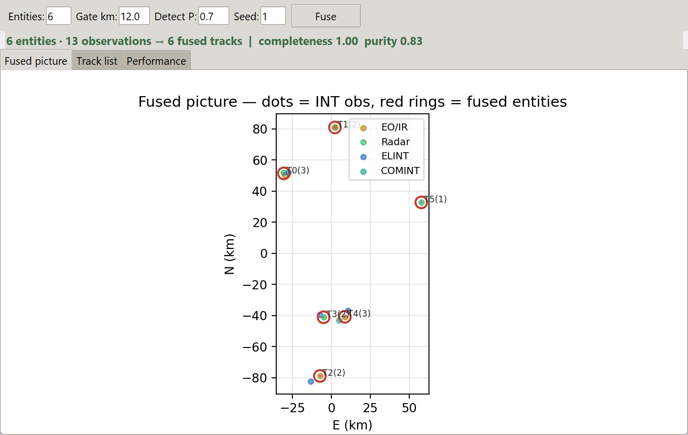
Multi-INT fusion — fused track picture
Layered COP

Theatre, tactical and 3-D — one coupled frame

  • Geographic theatre on an offline world-map basemap; drill into the tactical x/y-km engagement frame; a 3-D altitude view
  • MGRS grid readout, range/bearing measurement, and geofence zones (no-fly / restricted / engagement area) that raise alerts on breach
  • Select any track to drill from theatre straight into the tactical frame
  • Trails follow moving tracks; save and reload the operator picture (classifications + zones)
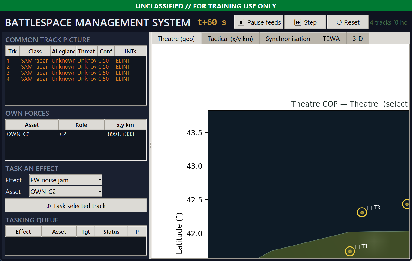
OAK BMS — layered common operating picture
Evaluate & task

TEWA — what to engage, with what

  • Threat evaluation & weapon-target pairing: threats ranked by level, CPA and urgency, each with a recommended effector — the operator approves
  • Task EW jam, GNSS denial or cyber against a track — scored by the suite's own physics models
  • Multi-domain synchroniser sequences effects on a battlespace clock; spectrum fratricide flagged when own effects overlap in band and time
  • Combined mission-effect read-out across every tasked domain
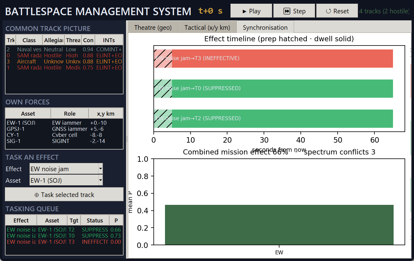
OAK BMS — effect timeline & combined mission effect
Decide · confirm · review

Alert, classify, record and debrief

  • Operator classification sticks to a track and follows it — re-applied every cycle
  • Kinematics: course, speed and closest-point-of-approach to own assets; threat alerting on engagement-ring and zone breaches
  • Record / replay / scrub the engagement; generate a self-contained after-action report
  • Export the picture — KML/KMZ for Google Earth/QGIS, CSV track list, and a SITREP carrying the classification
  • Role-based access, sign-in, classification banners and an audit trail of every operator action
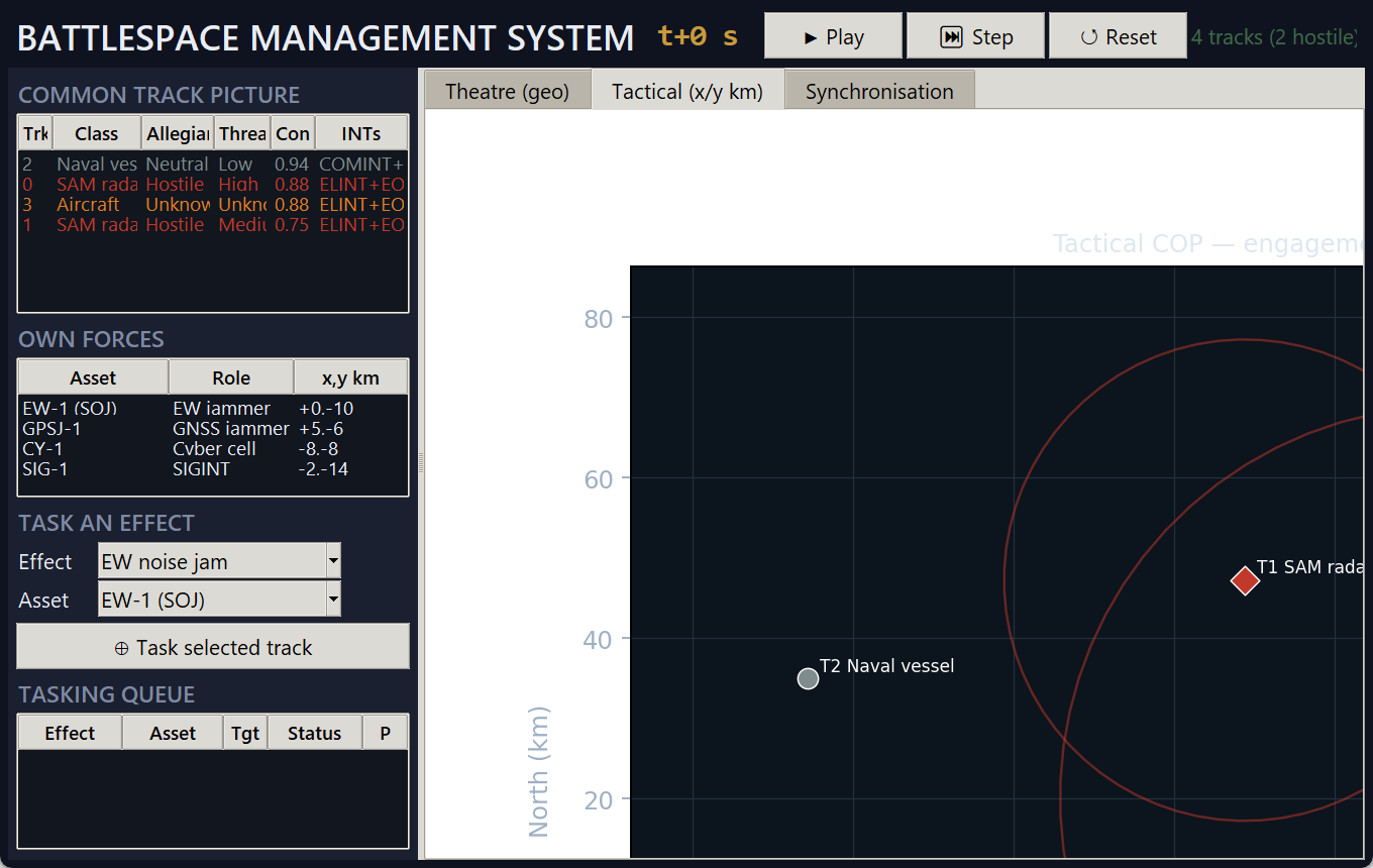
OAK BMS — tactical engagement frame with hostile rings
All-domain · ISR-managed · trusted

The whole fight — managed and accountable

The COP spans every domain, closes the collection loop, and makes every AI-fused track and operator decision defensible.

All-domain in one COP

Air and surface tracks join subsurface sonar contacts, a space catalog with conjunction warnings, counter-UAS tracks with recommended defeats, and a NAVWAR contested-PNT overlay — fused on one battlespace clock.

ISR management loop

Set intelligence requirements and Named / Target Areas of Interest; a live collection plan shows coverage and gaps, cues the right sensor, and tracks each requirement to SATISFIED. Analyst PED ties a track to a requirement and exports an INTREP.

Trusted, accountable AI

Emitters are auto-identified and fingerprinted to the specific unit; every fused track carries a calibrated confidence and a GO / CAUTION / NO-GO gate before an effect; every decision lands on a tamper-evident record.

Interoperate

Speaks the standards your kit already speaks

Take a picture in from TAK and the network; push it back out to TAK, Google Earth and other consoles. Open, inspectable formats — no proprietary lock-in.

Cursor-on-Target ⇄ TAK

Ingest CoT events from TAK / ATAK and other fielded C2, and emit the BMS picture as conformant CoT — affiliation and battle-dimension preserved both ways.

Shared picture, many operators

One console publishes over TCP; any number subscribe and see the same live COP. The network frame is the same as a recording — live share and replay are interchangeable.

Export to anywhere

KML / KMZ for Google Earth & QGIS, a CSV track list, and a plain-text SITREP that carries the current classification — get the picture into briefings and other tools.

MIL-STD-2525 / APP-6 symbology Cursor-on-Target 2.0 (TAK) MGRS / UTM grid KML / KMZ · GeoJSON ANPP INS/GNSS SCPI instruments
Live feeds

Wire it to your sensors — all receive-only

OAK BMS ingests over open, inspectable interfaces. Nothing transmits; the operator owns every sensor, link and authority.

Track-link RX

Geolocated track messages over TCP (newline-JSON): id, position, allegiance, class, threat and RF. The primary external picture source.

Cursor-on-Target RX/TX

CoT 2.0 events to and from TAK / ATAK and fielded C2 — interoperate with the systems your teams already field.

Multi-sensor ELINT RX

Two or more ESM stream PDWs (RF + AOA); cross-fixed to real positions with error ellipses, auto-identified to real-world systems, and fingerprinted to the specific emitter unit (SEI).

INS / nav RX

Own-platform position and attitude over the ANPP packet stream — anchors the theatre and tactical frames.

EO video RX

Motion-tracked electro-optical detections folded in as bearing observations for the fusion engine.

Spectrum (PXA / VSA) RX

Keysight PXA / VSA capture over SCPI — spectral peaks become ELINT detections at the analyser bearing (or simulated, hardware-free).

NAVWAR / GNSS RX

Models GNSS jamming & spoofing against own assets — denial rings and a per-asset PNT-integrity read-out on the COP for operating in contested PNT.

Undersea / ASW RX

Sonar contacts from sonobuoy / hull arrays, fused into the picture as depth-aware subsurface tracks alongside the air and surface tracks.

Space DA RX

Space-object catalog with conjunction screening (RED / AMBER / GREEN) — the orbital picture feeding the same console.

Counter-UAS RX

Small-UAS tracks classified by DoD group, each with a recommended soft-kill defeat (RF link-jam + GNSS denial) and probability.

Shared picture RX/TX

Publish the COP over TCP and let other consoles subscribe — one fused picture across many operators.

Record / replay FILE

Anchor-independent NDJSON recording with scrub and seek — replay a real engagement for training or after-action.

Verification & validation

Evidence, not adjectives

Every quantitative claim is auditable. A requirements-traceable V&V harness runs the live code against analytical, surveyed and standard references — coordinate fidelity, MGRS, geolocation accuracy (Monte-Carlo CEP/RMS), tracker error, CoT conformance, physics-consistency, performance and robustness — and gates every check in CI with a coverage floor, so the evidence can't silently rot.

  • 14 requirements · 35 checks · all within acceptance, traceability matrix in the report
  • AI integrity verified — the confidence calibration doesn't worsen error, the provenance gate separates single-source from corroborated tracks, and the decision record detects tampering (REQ-BMS-014)
  • Real-socket interoperability conformance tests (CoT in/out, shared picture)
  • Validated in an overnight full-suite + 8-hour soak; role-based access, classification banners and a full audit trail

Engineering evidence — not an accreditation. ATO, classification and field test against your sensors remain the deploying authority's responsibility.

35V&V checks — all pass
~87%code coverage, CI-gated
1.3 kmtracker RMS (from 2 km noise)
<1.7 kmgeolocation RMS (3 ESM)
Built to deploy

Decision support — honest about what it is

OAK BMS helps an operator see, understand and decide. It is decision support, not a certified targeting or fires system — the operator owns verification, classification and export-control of every feed and authority.

All-domain COP ISR collection loopAI-integrity gate Tamper-evident decisionsReceive-only feeds CoT / TAK interopRole-based access & audit Offline world map / DTEDMulti-operator picture V&V + CI evidenceSingle offline installer

Run it on your picture

Bring a track-link or ESM feed — or use the built-in producer — and we'll stand up a live common operating picture with you.

Request a demo
OPERATOR-IN-THE-LOOP // DECISION SUPPORT — receive-only feeds · physics-based · honest by design